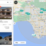
The California Geological Survey is helping state residents learn how close they live to a fault line, using
interactive maps that can be accessed via smartphone. Users can type in an address or share their location to see the nearest high-risk earthquake zone. The maps also reveal the risk of liquefaction—when land loses its stiffness under the stress of an earthquake and becomes like quicksand—or a landslide.
State lawmakers ordered the creation of the maps decades ago, but the information is usually shared in paper form or PDF format, which has made it difficult for homeowners to sort through. The CGS hopes that the maps will be easier to use now that they are available on smartphones.
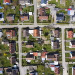
The maps allow users to zoom in on a property and see which parcels of land could be affected by earthquake hazards. The CGS says the main point of the maps is to give developers and prospective home buyers more information about a property’s disaster risks.
“An important thing to keep in mind is that the zones are a broad area where hazards may exist,” Tim McCrink, supervising engineering geologist and program manager for seismic hazards for the CGS, told
The Los Angeles Times. “The area where the ground actually fails in a particular earthquake may be only a small proportion of the total area in the zone.”
“It’s not a deal-killer just to have a property in the zone,” McCrink continued. “Knowledge is power. Before you buy your property, before you build ... do an investigation to see what your hazards are.”
To access the EQ Zapp,
visit conservation.ca.gov/cgs.
Source: “Worried About Being on Top of an Earthquake Fault? New California Maps Will Let You Know on a Smartphone,” Los Angeles Times (March 23, 2018)